In this story
- Start with a sentence, not a protractor
- Why AI translates, while your phone calculates
- The geometry of two pins and four heights
- Why a church tower alignment lasts ninety seconds
- First and last direct sunlight on real terrain
- Save the plan, then let the weather engine earn its keep
- The $99 question: 3D planning subscriptions vs. a $5 indie app
Start with a sentence, not a protractor
Almost every sun or moon alignment starts the same way in a photographer's head. You are walking across a bridge, standing on a hillside above town, or looking across an alpine valley at a sharp granite peak, and you think: what if a full moon rose right behind that church tower?
Notice what is not in that thought. You do not think, I wonder when a 98%-illuminated waxing or waning lunar disc next crosses azimuth 101.5° at an apparent altitude of 2.7° within a ±0.5° cone from a viewpoint 488.37 metres away.
Yet for the last decade, planning that photograph meant translating your visual idea into a spreadsheet of bearings, vertical elevation angles, height offsets and angular tolerances before you could even find out whether the geometry ever works from that spot. If you got one height wrong, or forgot to account for the building you were standing on, the date was either wrong or the search came back empty.
With the new Find / Load / Save workflow inside the 3D Diorama, I wanted to close the gap between the photograph in your head and the trigonometry required to test it. You drop your photographer pin where you want to stand, place your subject pin on the church tower, lighthouse, castle or mountain peak you want to frame, open Find in the 3D Diorama, and simply ask:
Or, if you are planning an alpine ridge or a city street without a specific building in mind: “Full moon rising low in the east this autumn”, or “When does first direct sunlight hit my viewpoint in winter, sorted by the lowest sun angle first?” You can even plan for solar and lunar eclipses - checking the exact azimuth, altitude and obscuration percentage of an eclipsed sun or moon over your chosen landmark in the 3D Diorama and saving the setup as a shooting plan for eclipse day.
Why AI translates, while your phone calculates
If you have ever asked a general-purpose chatbot when the full moon will sit behind a specific landmark, you already know what happens next: it sounds supremely confident and invents a date out of thin air. Large language models are pattern engines for language, not astronomical ephemeris solvers. Asking an LLM to compute lunar parallax in its head is like asking a poet to do long division blindfolded.
So Find with AI in Inverza follows a strict division of labour: the AI translates your intent into structured search settings, and your iPhone's deterministic astronomy and terrain engine calculates the dates on-device.
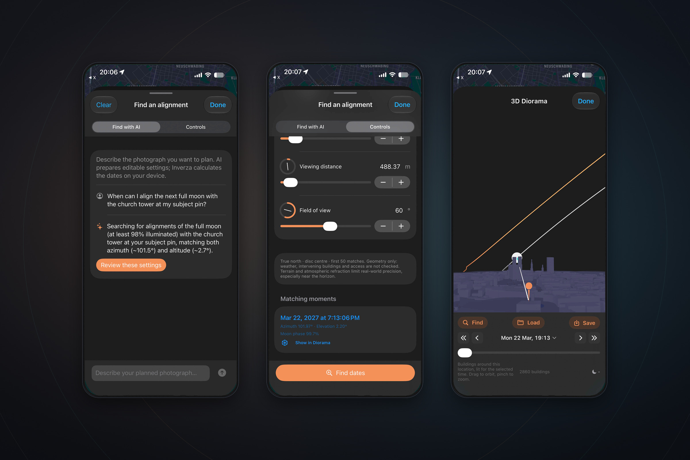
In the Munich church-tower example shown in the hero image above, here is what actually happens when you type that sentence:
- The scene context is already known. Because your photographer pin and your subject pin are placed in the 3D Diorama, Inverza already knows the true-north bearing between them (
~101.5°), the horizontal ground distance (488.37 m), the terrain elevation under both pins, and the OpenStreetMap building footprints loaded in the scene. - Find with AI fills out the Controls sheet for you. It selects the Moon, turns on Use subject pin, sets the moon phase filter to Full moon (≥ 98% illuminated), locks the target azimuth (
~101.5°) and target elevation angle (~2.7°) derived from the church tower, and explains its setup in plain English: “Searching for alignments of the full moon (at least 98% illuminated) with the church tower at your subject pin, matching both azimuth (~101.5°) and altitude (~2.7°).” - You stay in control. Tap Review these settings and the sheet switches straight to the manual Controls tab. Every slider - azimuth, elevation, angular tolerance, photographer height, subject height, viewing distance, field of view and date window - is right there in the open. Nothing is hidden inside a black box.
- Your phone solves the sky. Tap Find dates and Inverza sweeps your date window on-device, returning the exact matching moments - in this case 22 March 2027 at 19:13:06, when a 99.7% full moon sits at azimuth
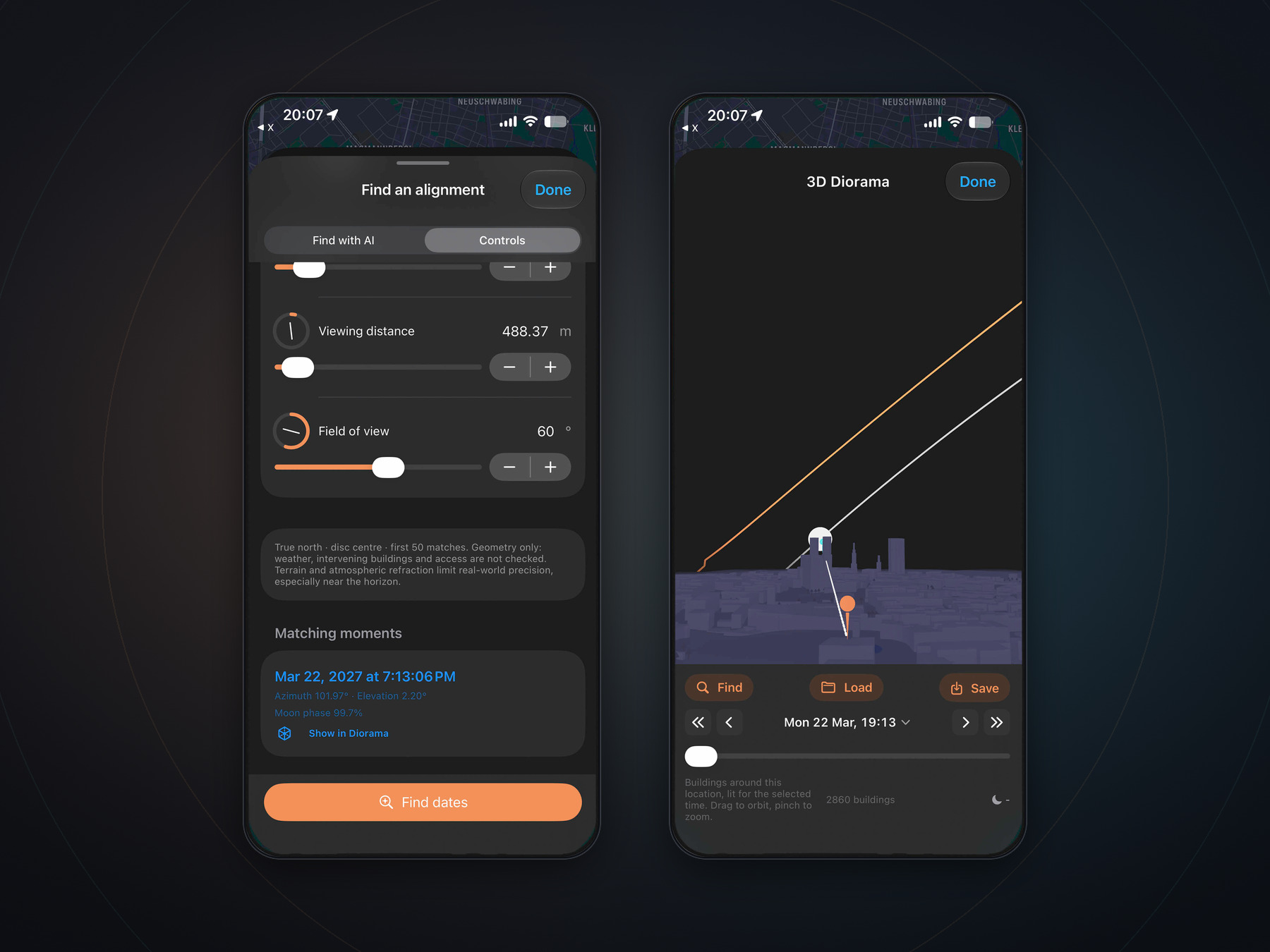
101.97°and elevation2.20°. Tap Show in Diorama and the 3D scene jumps straight to that minute, with the moon sitting directly behind the church tower among 2,860 3D buildings.
The geometry of two pins and four heights
Why is matching the sun or moon with a landscape feature harder than drawing a flat compass line on a 2D map? Because every real alignment is a three-dimensional sightline problem governed by two pins and four vertical numbers.
Four heights. One target angle.
- 1 Two ground elevationsBoth pins sample the same elevation datum so close-range city scenes and 40 km mountain views share a consistent vertical reference.
- 2 Automatic 3D roof heightsIn Automatic mode, Inverza reads OpenStreetMap building footprints in the Diorama: your eye sits 1.6 m above the ground or roof at your pin, and the target sits at the top of the subject's roof or spire.
- 3 Curvature, parallax & refractionThe solver converts both pins into your local tangent plane, applies Earth curvature, lunar topocentric parallax and atmospheric refraction, and checks when the disc centre enters your tolerance cone.
Because the sightline is defined by two points in 3D space, stepping 50 metres closer to a church tower or moving onto a balcony immediately changes the target elevation angle α - and therefore the minute (or even the month) when the moon aligns with it.
When you place a photographer pin and a subject pin in Inverza's 3D Diorama, the alignment engine (Find) resolves four physical layers before it ever looks at the sky:
- Shared terrain datum (h1 and h2). Both the camera pin and the subject pin are sampled against the same terrain elevation grid. That sounds like a small detail, but if you mix two different elevation sources across a 400-metre city sightline, a 5-metre datum discrepancy introduces more than half a degree of vertical error - wider than the entire moon!
- Automatic OpenStreetMap building heights (plus manual overrides). If you are photographing a church tower, lighthouse, castle or skyline, bare terrain elevation is only half the story. In Automatic height mode, Inverza inspects the 3D OpenStreetMap building footprints loaded around both pins: it places your camera at eye level (
1.6 mabove the ground or the highest mapped roof under your pin) and places the target point on top of the mapped roof at your subject pin. If an OpenStreetMap spire only carries a simplified roof tag, or if you want to aim at the base of a cliff or the tip of a 300-metre television tower, you can switch either pin to manual height (up to500 mfor the photographer and1,500 mfor the subject) and watch the target elevation angle update live. - Earth curvature in the observer's tangent plane. Across a
488 mneighbourhood view, flat-Earth rise-over-run is close enough. Across a30 kmalpine valley, the curvature of the Earth drops a distant mountain peak by roughly70 metresrelative to your local horizontal plane. Inverza computes the great-circle central angleΔσbetween your two pins on a mean spherical Earth (R = 6,371,008.8 m) and resolves the subject directly in your local tangent plane:
up = (R + hsubj) · cos(Δσ) − (R + hcam)andhorizontal = (R + hsubj) · sin(Δσ)
so the target elevation angleα = atan2(up, horizontal)is exact whether your subject is 80 metres down the street or 50 kilometres across a mountain range. - Lunar topocentric parallax and atmospheric refraction. The Sun is far enough away that its angle in the sky is nearly identical for any two observers in the same region. The Moon is right in our astronomical backyard: depending on where you stand on Earth's curved surface, topocentric parallax shifts the Moon's apparent position by up to a full degree - roughly two full moon diameters. Inverza's lunar calculator applies topocentric parallax with Earth flattening at your exact coordinates, then adds Bennett/Saemundsson atmospheric refraction near the horizon so low-angle moonrises and sunrises match what your lens actually sees.
Why a church tower alignment lasts ninety seconds
There is a subtle trap in writing an alignment finder that works on a phone without draining your battery. Suppose you want to search a full year of dates (365 days) to see when the full moon passes within ±0.5° of a narrow church tower.
The Sun and Moon move across the sky at roughly 15° per hour, or 0.25° per minute. That means the Moon crosses a 0.5° target window in less than two minutes. If an app searches a year by stepping forward in coarse 5-minute increments (1.25° of sky motion per step), the Moon can approach the church tower at 19:10, pass dead-centre behind the cross at 19:13:06, and exit the far side of your tolerance box before the next 5-minute check at 19:15. A naive 5-minute search would miss the alignment completely and tell you no match exists that year.
Checking every single second of a 365-day window would mean running more than 31 million astronomical evaluations on your phone. Instead, Inverza's alignment solver uses a two-stage bracket-and-refine strategy:
- Coarse local-minimum bracketing. As the solver steps through your date window in 5-minute intervals, it does not merely ask whether a 5-minute sample lands inside your
±0.5°tolerance. Instead, it tracks the combined angular distancemax(|Δazimuth|, |Δelevation|)between the Moon and your sightline ray. Whenever that angular error dips to a local minimum - even if the 5-minute endpoints sit up to3°outside your tolerance - the solver recognises that the Moon passed close to the target between those two samples. - Sub-second refinement. Each candidate bracket is then narrowed with a ternary search until the true closest approach is pinned down to within a quarter of a second (
0.25 s). Only after finding the exact second of closest approach does Inverza check whether that peak alignment satisfies your azimuth tolerance, elevation tolerance, rising/setting motion and lunar illumination filters.
That is why the match in the screenshot reads Mar 22, 2027 at 7:13:06 PM rather than a rounded 5-minute guess - and why a fleeting 90-second alignment with a distant spire or summit is caught reliably even across a full-year search.
First and last direct sunlight on real terrain
Not every planned photograph is about catching the solar or lunar disc behind a tower. Just as often, the question is simpler and equally decisive: what minute does the first direct ray of morning sun clear the mountains to the east and hit my viewpoint (or my subject), and which days of the year give the lowest, warmest grazing angle?
Sea-level sunrise tables cannot answer that in the mountains or in a dense city. As we explored in Standing in shadow, photographing in light, a valley floor can sit in deep mountain shade for forty minutes after nominal sunrise while the peak opposite is already glowing.
Inside the same Find sheet, switching the Sun search to First direct sunlight or Last direct sunlight runs a dedicated terrain-grazing solver:
- It builds a quantitative 360° horizon profile around your target pin (either your photographer pin or your subject pin) out to 50 kilometres from NASA SRTM elevation tiles, sampled every
0.25°in azimuth - stepping every15 mnearby, every30 mout to 20 km, and every150 mout to 50 km - and merges in the loaded 3D OpenStreetMap buildings around the pin. - For every day in your date range, it tracks the Sun's upper limb (adding the Sun's
~0.267°apparent radius to its refracted centre altitude) against the exact terrain and building horizon height at the Sun's azimuth, refining the moment the disc clears or drops behind the ridge to within 30 seconds. - If you sort by Lowest sun angle first, Inverza ranks the matches by the shallowest grazing elevation - surfacing the days of the year when the sun clears a low gap in the ridge rather than emerging high and harsh from behind a nearby shoulder.
Save the plan, then let the weather engine earn its keep
When you find a date like 22 March 2027 at 19:13:06, you rarely shoot it tomorrow. You plan it on a rainy Tuesday in October and need it ready five months later.
Tapping Save in the 3D Diorama stores the entire shooting plan on your device: both the photographer and subject coordinates, ground elevations and marker heights, the matched date and time, your exact 3D camera orbit and field of view (60° in the example above), all of your Find settings, and your own field notes. Tapping Load weeks or months later restores the whole scene - moving to the saved spot if needed, rebuilding the 3D terrain and buildings, and putting the camera right back on your saved sightline so you can refine the composition or save a variant.
A necessary dose of honesty belongs here, too - the same caveats printed right inside the Find sheet:
- Geometry is not a sightline survey. Find computes exact astronomical and terrain/building angles, but it does not check whether an unmapped tree, a crane, a courtyard wall or a locked gate stands between your tripod and the subject.
- OpenStreetMap building heights are community data. In well-mapped cities, 3D building footprints and heights are remarkably faithful, and the Diorama shows you right at the bottom how many buildings are loaded (
2860 buildingsin the Neuschwabing view). Where a church spire's cross is taller than its tagged roof outline, use the manual subject height slider to add those extra metres. - Refraction near the horizon varies with the weather. Below
2°elevation, temperature inversions can bend light slightly more or less than the standard atmosphere model assumes.
And when the week of your saved plan finally arrives, you do not have to copy coordinates into a second app to find out whether the sky will cooperate. Your spot is already inside Inverza's eight-source weather engine, with 16 photographic condition detectors (including Full Moon Silhouette, Afterglow Sunset and Colorful Dawn), directional cloud checks out to 450 km along the twilight ray, and AR Sky ready to verify the exact frame through your phone's lenses on location.
The $99 question: 3D planning subscriptions vs. a $5 indie app
If you have read our guide to the 5 apps on every landscape photographer's home screen, you already know that I have huge respect for classic ephemeris tools like PhotoPills. We put it at #1 on that list, ahead of our own app, because a dedicated optical and ephemeris toolkit has earned its place in every photographer's camera bag.
At the same time, the photography software world is shifting rapidly. As 3D terrain planning, satellite views and cloud-synced workflows move into high-tier annual subscriptions - with premium planning tiers in our niche now reaching up to $99 USD per year - a lot of photographers are understandably asking whether 3D alignment planning really has to cost as much as a desktop editing suite, or whether a small, independent $4.99/year (~$5 USD) app can genuinely hold its own.
My philosophy with Inverza is simple: focus on the capabilities that actually decide whether you come home with the photograph, and include all of them in a single, accessible tier.
What $4.99/year includes in Inverza vs. typical high-tier planning subscriptions
- Find with AI + deterministic solver: Describe the alignment in plain English, inspect the editable settings, and compute sub-second matches on-device.
- 3D terrain + 3D OpenStreetMap buildings: Real terrain, coastlines, trees and thousands of 3D city buildings in the 3D Diorama and on the 2D Shadow Map.
- Two-pin height intelligence: Automatic roof/eye heights from 3D buildings plus manual overrides up to 1,500 m.
- First & last direct sunlight: 50 km SRTM + building horizon solver with lowest-sun-angle ranking.
- Solar & lunar eclipse planning: Built-in NASA/GSFC Besselian solar eclipse geometry through 2030, lunar eclipse alignment framing in 3D, and live AR Sky camera verification.
- 8-source weather intelligence: 16 photo condition detectors, 450 km twilight ray-tracing, raw weather charts, alerts and AI weather chat included.
- Deep optical & exposure tables: Dedicated depth-of-field, hyperfocal, star-trail length, time-lapse interval and meteor-shower calculators.
- Manual multi-panel ephemeris workflows: Built for photographers who prefer dialling every azimuth, elevation and lens parameter manually across dedicated calculator modules.
- Separate from weather interpretation: Geometry planners generally leave cloud layers, fog physics, inversions and twilight colour to a separate weather app.
If your work relies every week on hyperfocal distance tables, star-trail exposure calculators, or meteor-shower radiant charts, a classic dedicated calculator app remains indispensable. Nothing in Inverza tries to replace a depth-of-field table.
But if the reason you want a 3D planner is to answer the two questions that actually make or break a landscape or cityscape photograph - “when will the sun or moon line up with that mountain, church tower or skyline?” and “will the sky actually be worth the alarm when that day arrives?” - you do not need to spend $99 a year to get first-class 3D terrain, 3D building skylines, sub-second alignment math, natural-language setup and multi-model weather intelligence.
Inverza is built by one photographer, with no venture capital, no ad tracking and no tier gates. Every feature - the 16 weather detectors, the 8-source forecast engine, AR Sky, the 2D terrain and building shadow map, and the complete Find / Load / Save 3D alignment studio - is included in the same $4.99/year subscription after a 14-day free trial. That is one-twentieth the price of a $99/year subscription, or roughly the cost of the coffee you drink in the car park while waiting for moonrise.
Next time you walk past a church tower, a lighthouse or a ridge and wonder if the full moon ever sits right where you want it, drop two pins in the 3D Diorama and ask in plain English. Your phone will handle the trigonometry. You just have to be there when the moon arrives.
